Mapping Food Flow Networks and the Food Supply Chain, Part 1
Food supply chains are complex systems that incorporate production, distribution, intermediate processing, and consumption of food commodities. Food flow networks represent the movement of food through these complex supply chains. Food flow networks depend on many factors, such as production locations, population centers, storage, and transport infrastructure. To help develop a better understanding of food flow networks, in this article we (1) describe two national databases of food flows within the United States, and (2) introduce our research to estimate food flows between U.S. counties.
Background: Census Data on Food Flows
The Commodity Flow Survey (CFS) is the main source of domestic freight shipments by American businesses. The CFS is a joint effort of the U.S. Census Bureau and the Bureau of Transportation Statistics to help policy makers and transportation planners assess the demand for transportation, energy use, and risk assessment (U.S. Census Bureau, Commodity Flow Survey). The CFS is a shipper-based survey that collects information on how U.S. establishments transport raw materials and finished goods for the manufacturing, mining, wholesale, selected retail, and services establishments. The CFS collects data on the types of commodities shipped by mode of transportation, including their value, weight, origin, and destination (including exports).
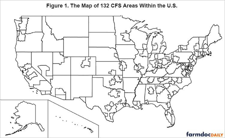
Data is provided for commodity flows between roughly 132 spatial zones (e.g., CFS areas) in the United States. CFS areas are generally the 50 states and several Metropolitan Statistical Areas. The geographical units of the CFS database are shown Figure 1. The CFS is conducted every five years (ending in ‘2’ and ‘7’). CFS data is collected for commodities according to the Standard Classification of Transported Goods (SCTG) categories. Table 1 provides the agricultural and food SCTG categories.
The Freight Analysis Framework (FAF) builds on the CFS data, but now also incorporates international trade data from the Census Bureau, to determine international shipments within U.S. supply chains. FAF is reported by the U.S. Department of Transportation’s Federal High Administration (USDOT-FHA, Freight Analysis Framework). CFS also relies on sampling and covers about 100,000 establishments that ship freight domestically, mostly in the mining, manufacturing, and wholesaling industries. But FAF combines supplementary data to estimate shipping quantities from establishments not covered by the CFS. The same regional locations, time scales, commodity categories, and modes of transportation are used in both FAF and CFS data.
Table 1. List of SCTG Food Commodity Groups in This Study
| SCTG code | Food commodity |
| 01 | Live animal and fish |
| 02 | Cereal grains |
| 03 | Agricultural products (except for animal feed, cereal grains, and forage products) |
| 04 | Animal feed, eggs, honey, and other products of animal origin |
| 05 | Meat, poultry, fish, seafood, and their preparations |
| 06 | Milled grain products and preparations, and bakery products |
| 07 | Other prepared foodstuffs, fats, and oils |
| All | All agri-food commodities aggregated |
Discussion
Estimates of Food Flows Between Counties
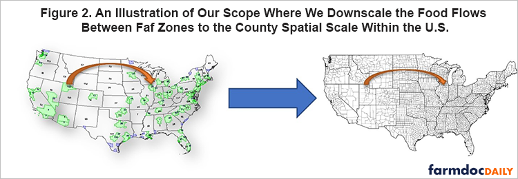
We develop the Food Flow Model to estimate agricultural and food flows between counties in the U.S. This approach downscales data at the FAF scale to the county scale as shown in Figure 2. We use the exact same SCTG food commodities as do the CFS and FAF databases (see Table 1). To downscale, the Food Flow Model incorporates (i) logistic regression, (ii) gamma regression, (iii) gravity model structure, (iv) mass balance, and (v) linear programming. Briefly, our approach fits regression functions to each empirical SCTG commodity network at FAF scale. Then, variables in these regression functions are replaced with their corresponding values for each county as we assume that the regression formulations are constant across spatial scales. Please refer to our manuscript for more detail.
The Food Flow Model relies on multiple empirical data to estimate county-level food flows. Input data include multiple variables such as the geography of production, transportation, input-output requirements, and consumption that combine to determine food transport. In the model, consumption is not restricted to the purchase of final goods by households, but instead also accounts for the intermediate stages in supply chain production and processing. Every time there is a transformation of commodities from raw to more refined items there is a new link in our database. For example, live animals that are sent to a slaughterhouse are transformed into meat, so the counties containing the slaughterhouses consume the live animals and produce meat. We ensure that food flows of counties sum to the larger FAF zones that they are contained within.
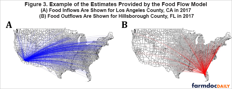
We estimate food flows over 9 million origin and destination pairs for each commodity. Figure 3 illustrates the estimates that we make. For each county, we estimate whether or not it is connected to every other county in the United States. We also estimate the mass flux in kilograms that is carried along each origin-destination pair. We do this for each SCTG category provided in Table 1 individually.
Estimates By Commodity
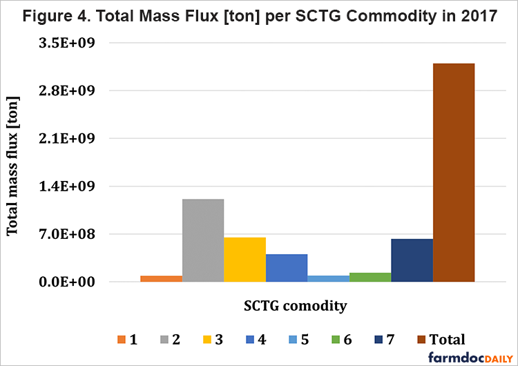
We estimate county scale food flows for each SCTG commodity. Each SCTG commodity has a different total mass flux in 2017, as seen in Figure 4. SCTG 02 (cereal grains) has the highest total mass flux among all individual food groups. This is because the U.S. is a top producer and exporter of cereal grains such as corn and wheat. Note that the mass flux is identical across FAF and county scale databases by design.
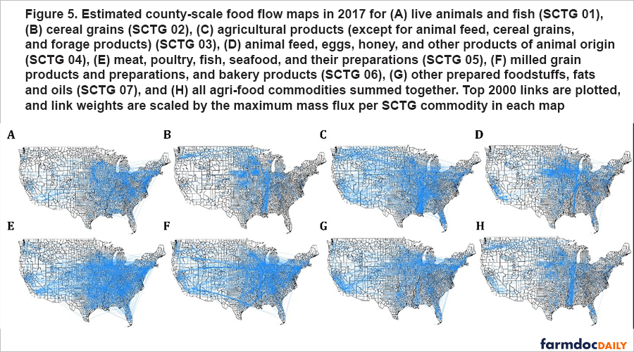
Figure 5 provides maps of county-scale food flows by commodity for the year 2017, which is the year with the most up-to-date data available. The total mass flux contained within each map varies according to Figure 4. This illustration highlights the goal of our study which is to determine spatially detailed maps of food flows by commodity, since this could be useful for future research, decision-making, and policy.
The Mississippi river-bend is one of the regions with the highest mass of food flows. This is particularly notable for all agri-food commodities aggregated (Figure 5H), and cereal grains (Figure 5B). This makes sense, since the Corn Belt and Mississippi river bend are major grain corridors for agri-food distribution (by moving grain to/from Port of NOLA), especially in terms of mass. Figure 4 highlights the mass flux of different agricultural and food commodities. It is important to note that the maps in Figure 5 would look different if they were scaled in terms of dollar value of food shipments.
Food Flow Visualization
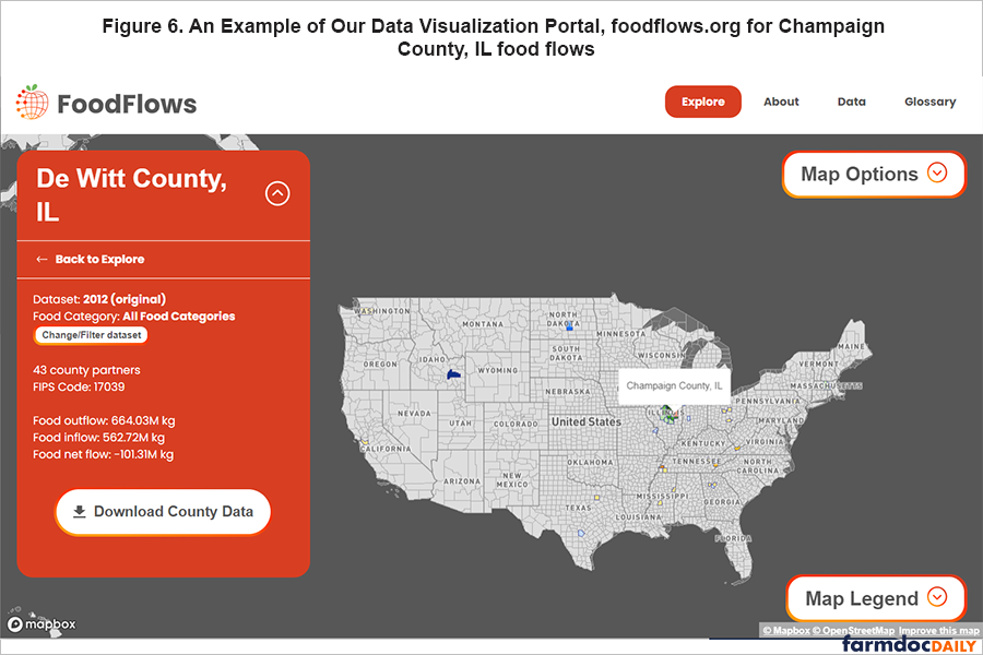
We estimate about 70 million data points in each year of our study. We make this information freely available at foodflows.org so that those who are interested can dig into the data and visualize a county of interest. We provide an example of the website for the county of Champaign, Illinois in Figure 6. Interested readers are encouraged to go to foodflows.org to engage with the data.
Conclusion
Here, we describe two national databases of food flows within the United States and introduce our research to map food flows across commodities at a finer spatial scale to better understand the national food supply chains. Our research contributes to a more comprehensive picture of our national food system for researchers and policymakers, as our county spatial scale food flow estimates are well suited for national-level analyses. We also make our 70 million data estimations openly and freely available at https://doi.org/10.13012/B2IDB-9585947_V1 to encourage further scientific study on our national food supply chains.
References
Karakoc, D. B., J. Wang, & M. Konar (2022). Food flows between counties in the United States from 2007 to 2017. Environmental Research Letters, 17(3), 034035.
Lin, X., P.J. Ruess, L. Marston, and M. Konar (2019) Food flows between counties in the United States, Environmental Research Letters, 14(3).
BEA 2020a US Bureau of Economic Analysis, Personal Income (available at: www.bea.gov/data/gdp/gdp-county-metro-and-other-areas)
BEA 2020b US Bureau of Economic Analysis, Input–Output Accounts Table (available at: www.bea.gov/industry/input-output-accounts-data)
Oak 2020a Oak Ridge National Laboratory County-to-County Distance Matrix (available at: https://tedb.ornl.gov/)
Oak 2020b Oak Ridge National Laboratory Freight Analysis Framework (available at: https://faf.ornl.gov/faf5/)
POR 2020 US Bureau of Transportation Statistics Port Trade Data (available at: www.bts.gov/transborder)
USC 2020a United States Census Bureau, Population (available at: www.census.gov/data/datasets/time-series/demo/popest/2010s-counties-total.html)
USC 2020b United States Census Bureau Land Area of Counties (available at: www.census.gov/library/publications/2011/compendia/usa-counties-2011.html)
USC 2020c United States Census Bureau, North American Industry Classification System (available at: www.census.gov/naics/)
USD 2020a United States Department of Agriculture (available at: https://quickstats.nass.usda.gov/)
USD 2020b United States Department of Agriculture Economic Research Service (available at: www.ers.usda.gov/data-products.aspx)
Disclaimer: We request all readers, electronic media and others follow our citation guidelines when re-posting articles from farmdoc daily. Guidelines are available here. The farmdoc daily website falls under University of Illinois copyright and intellectual property rights. For a detailed statement, please see the University of Illinois Copyright Information and Policies here.


